- Main target area associated with 100 metre-wide major shear zone -
Vancouver (August 8, 2019) Solstice Gold Corp. (“we”, “our” “the Company”) (SGC:TSX.V) is pleased to announce the successful completion of field mapping on part of our 928 km2 Meliadine area property in Nunavut. Mapping has significantly advanced our understanding of the geology of the 50 km2 target area, referred to as “Enterprise”. As a result, the company has initiated drilling on several priority targets described in more detail below.
The main purpose of the program was to test our model of the Enterprise area and to develop data to better understand geological and structural controls prior to diamond drilling. The Enterprise area lies adjacent to and on strike of leases owned by Agnico on which drilling in 2005 returned up to 9.6 g/t over 3.2 m (Aqpiq showing*). Gold at Aqpiq is developed within iron formation and is closely associated with major faulting. A key objective of the Solstice program was to determine if the same geological sequence extends onto Solstice claims in an area which is coincident with a 5 km2 area of distinctive magnetic depletion. A summary geological map with currently planned drill hole locations is provided in Figure 1 and proposed drill holes are presented in Table 1.
Field Program Highlights
Mapping has discovered a major shear zone (mylonite) which outcrops over a true thickness of over 100 m. The shear zone is the extension of a regional (at least 80 km long) structure we refer to as the Raptor-Westeros Fault Zone (RWFZ). Intensely deformed and rodded K-Spar-bearing rocks indicate a steep north dip with ‘north side up’. Lineation data plunge to the west at 5-15° with additional field observations indicating a right-lateral/dextral sense of movement.
The RWFZ abruptly cuts off and abuts a sequence of iron formation-bearing rocks which defines a 5 km2 block (“Enterprise Block”) which has been rotated clockwise through approximately 20° compared to the regional east west strike (Figure 1). Much of the Enterprise Block is occupied by lake (“Enterprise Lake”) but iron formation is mapped both to the northwest and southeast of the lake suggesting that observed magnetic trends are a continuation of the same iron formation units beneath the lake, albeit rotated and significantly less magnetic. Iron formation in bedrock along the western and southern shore of the lake is intermittently gold-bearing over a strike length of 6.8 km (see Figure 1).
As is the case at Meliadine, all observed plunges in the Enterprise area are approximately 5-15° to the west. This plunge direction will likely influence the controls of the orientation of any mineralization in the area.
“We interpret, based on the new data summarized above, that the large magnetic depletion area and rotated Enterprise Block represents a ‘releasing bend’ associated with the observed and mapped shear zone. This is a classic setting for so-called ‘orogenic’ gold deposits around the world. The presence of gold in bedrock around the edge of the main target area as well as significant intercepts on adjacent Agnico claims to the west suggests that the Enterprise Block may represent a significant zone of extension and space creation permissive for additional gold mineralization.” stated David Adamson, Executive Chairman.
Diamond Drill program
A total of eleven targets are planned to be test targets as summarized in Table 1 and Figure 1. The objective of these holes is to test for the presence of gold-bearing rocks in multiple settings within the Enterprise area. Given the scale of the target area which itself is part of a much larger 928 km2 property, this preliminary program is testing only a portion of the available targets and is restricted to land-based targets. Additional information can be found on our investor presentation at https://www.solsticegold.com/investors/presentations/
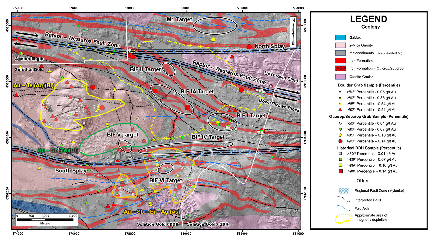
Figure 1: Compilation map (Geology/Digital Elevation model base) of the Greater Enterprise area, showing the location of upcoming drill target areas.
| Target | Interpretation | Drilling |
| M1 | 2.3 km (unfolded) BIF in thickened fold nose. Hanging wall to RWFZ and interpreted to be on strike to Aqpiq gold occurrence (Agnico) which host up to 9.6g/t gold over 3.2 m. Recent 2019 mapping identified sedimentary rocks within 0.5km of the target in outcrop, confirming the interpretation. Strong magnetic and electromagnetic expression | One initial hole to test the strongest magnetic and EM expression of the target. |
| BIF I | Very strong EM conductor on all frequencies with coincident magnetic response at bend in stratigraphy of BIF I. Part of 6.7 km interpreted BIF unit supported by mapping immediately on strike to the east in 2019. | One hole to test strongly conductive body. Contingent follow up best done from ice. |
| BIF Ia | 2.3km long NW trending portion of BIF I, part of 6.8km long inferred unit. Stratigraphy here is rotated through 20 degrees from the regional strike as part of a large rotated block (Enterprise Block). Two incomplete holes were completed by Kaminak in 2006**. Both holes intersected iron formation which, based on core-foliation data and inspection of photographs of core is up to 26 m minimum true thickness in one hole. Maximum gold of 7.2 g/t over 0.69m in hole stopped in iron formation at 45m depth. Local EM response. | Two holes along strike of former holes planned to transect the iron formation unit. |
| BIF II | North central part of the 7.5 km2 rotated Enterprise block in a fault jog associated with the RWFZ. Beneath Enterprise Lake and core of a large associated magnetic low. Within 250 m and footwall to the 100 m+ wide RWFZ. Mapping in 2019 confirms that BIF is present in three units (I-III) on the east side of the lake and that these units reappear on the NW shore of the lake trending onto adjacent (Agnico) claims. It is considered likely therefore that the same units underlie the lake where they are both rotated and where they exhibit considerably lower magnetic signature. | One hole to be drilled from centre of Lake to test for presence of permissive stratigraphy and possible mineralization. |
| BIF-IV | Minimum 5 km long magnetic, east-west trending, variably magnetic trend with local conductivity. Occurs in close proximity to the regionally extensive Southern Splay Fault Zone which is located based on topographic and EM response. Forms approximate northern limit of, and thus the potential source of, extensive boulder train of elevated gold +/-Sb, Bi, Ag (As) in boulders and elevated gold in till samples***. No outcrop | Three holes to test variable magnetic and conductive parts of the unit. |
| BIF-V | Very variable magnetic 1.6 km long east-west trend parallel to BIF IV in potentially focused up ice portion of the gold-in-boulder train | Two holes testing magnetic low and high, respectively. |
| BIF-VI | Interpreted to be tightly folded iron formation occupying the hinge of the Westeros fold | One drill hole testing across the interpreted fold hinge. |
Table 1: Proposed target areas.
| Area | Type | Number of samples | Range g/t gold | 80th %ile g/t gold | 85th %ile g/t gold | 90th %ile g/t gold |
| Enterprise Target | Boulder (grab) | 752 | 0.005-54.9 | 0.35 | 0.54 | 0.94 |
| Outcrop/Subcrop (grab) | 86 | 0.005-5.47 | 0.07 | 0.10 | 0.14 |
Table 2: Distribution of gold samples from Boulder and Outcrop/Subcrop grabs from the Enterprise Target area.
1 Assay results from grab samples (boulders and outcrop) are selected samples and are not necessarily representative of the mineralization hosted on the property. Grab sample weights range from 0.75 kg to 3 kg. See Solstice news release dated November 13, 2018 for additional information and disclosure.
*This news release contains information with respect to the Meliadine, Amaruq and Meadowbank gold deposits along with other gold targets owned by Agnico Eagle Mines, in respect of which the Company has no interest or rights to explore or mine. Readers are cautioned that the Company has no interest in or right to acquire any interest in any such properties, and that mineral deposits on adjacent or similar properties are not indicative of mineral deposits on the Company’s properties and there is no certainty of the same or similar deposits on the Company’s properties.
**Kaminak Gold Corp drilled and/or analyzed 459 metres of core in five holes on the project. One of the holes appears to have completely missed its target while the other four appear to have incompletely tested their targets. Three of these holes documented gold including hole KCF-01 which showed visible gold and bottomed in Iron formation but was shut down early due to technical issues. This hole was never followed up on. (For additional information see Kaminak Gold Corp news release dated June 6, 2006.
***Till samples were analyzed at C.F. Minerals Research Ltd. in Kelowna, British Columbia. The lab is both ISO 9001:2008 certified and ISO 17025:2005 compliant. At CFM, samples were weighed, dried and processed. At CFM a series of heavy magnetic, paramagnetic and nonmagnet fractions are produced by wet sieving, heavy liquid concentrations (Tetrabromoetane and Methylene Iodide) and magnetic separation. The -80 mesh (< 0.177mm) heavy non-magnetic fraction is then sent directly to Activation Laboratories Ltd. (ActLabs) of Ontario, Canada. Samples were analyzed for gold at Actlabs using Instrumental Neutron Activation Analysis (INAA).
About Solstice
Solstice is a new gold-focussed exploration company engaged in the exploration of its 928 km2 (100%) district scale Kahuna Project and certain other rights covering an adjacent 805 km2, all with no underlying option or earn in payments. Kahuna is located in Nunavut, Canada only 26 km from Rankin Inlet and approximately seven km from the Meliadine gold deposits owned by Agnico Eagle Mines Ltd. Solstice has 69.5 million shares outstanding.
Solstice is committed to responsible exploration and development in the communities in which we work. For more details on Solstice Gold and the Kahuna Project please see our Corporate Presentation available at www.solsticegold.com.
Neither TSX Venture Exchange nor its Regulation Services Provider (as that term is defined in the policies of the TSX Venture Exchange) accepts responsibility for the adequacy or accuracy of this release.
Ian Russell, P.Geo., Vice President Exploration, is the Qualified Person as defined by NI 43-101 standards responsible for reviewing and approving the technical content of this news release.
On Behalf of Solstice Gold Corp.
David Adamson, PhD
Executive Chairman
For further information please visit our website at www.solsticegold.com or contact:
Marty Tunney, PEng
President
info@solsticegold.com
Forward Looking Statements
This news release contains certain forward-looking statements (“FLS”) relating but not limited to the Company’s expectations, intentions, plans and beliefs. FLS can often be identified by forward-looking words such as “emerging”, “goal”, “plan”, “intent”, “estimate”, “expects”, “scheduled”, “may” and “will” or similar words suggesting future outcomes or other expectations, beliefs, plans, objectives, assumptions, intentions or statements about future events or performance. FLS in this news release also include, but are not limited to, the extent and timing of described programs and ground work, such as rock sampling, drilling, geophysics, mapping, till sampling and analysis. FLS in this news release include comparison with certain geological features at an adjacent development property. There can be no guarantee that continued exploration at Kahuna, which is at an early stage of exploration, will lead to the discovery of an economic gold deposit. Factors that could cause actual results to differ materially from any FLS include, but are not limited to, delays in obtaining or failures to obtain required governmental, environmental or other project approvals, inability to locate source rocks, inflation, changes in exchange rates, fluctuations in commodity prices, delays in the development of projects, regulatory approvals and other factors. While the Company believes the boulders are sourced locally for the reasons outlined in this news release, there can be no certainty that their source is local, or that it will be located on Solstice claims. FLS are subject to risks, uncertainties and other factors that could cause actual results to differ materially from expected results.
Potential shareholders and prospective investors should be aware that these statements are subject to known and unknown risks, uncertainties and other factors that could cause actual results to differ materially from those suggested by the FLS. Shareholders are cautioned not to place undue reliance on FLS. By their nature FLS involve numerous assumptions, inherent risks and uncertainties, both general and specific, that contribute to the possibility that the predictions, forecasts, projections and various future events will not occur. Solstice undertakes no obligation to update publicly or otherwise revise any FLS whether as a result of new information, future events or other such factors which affect this information, except as required by law.
This news release contains information with respect to adjacent or similar mineral properties in respect of which the Company has no interest or rights to explore or mine. Readers are cautioned that the Company has no interest in or right to acquire any interest in any such properties, and that mineral deposits on adjacent or similar properties are not indicative of mineral deposits on the Company’s properties. Past performance is no guarantee of future performance and all investors are urged to consult their investment professionals before making an investment decision. Investors are further cautioned that past performance is no guarantee of future performance.